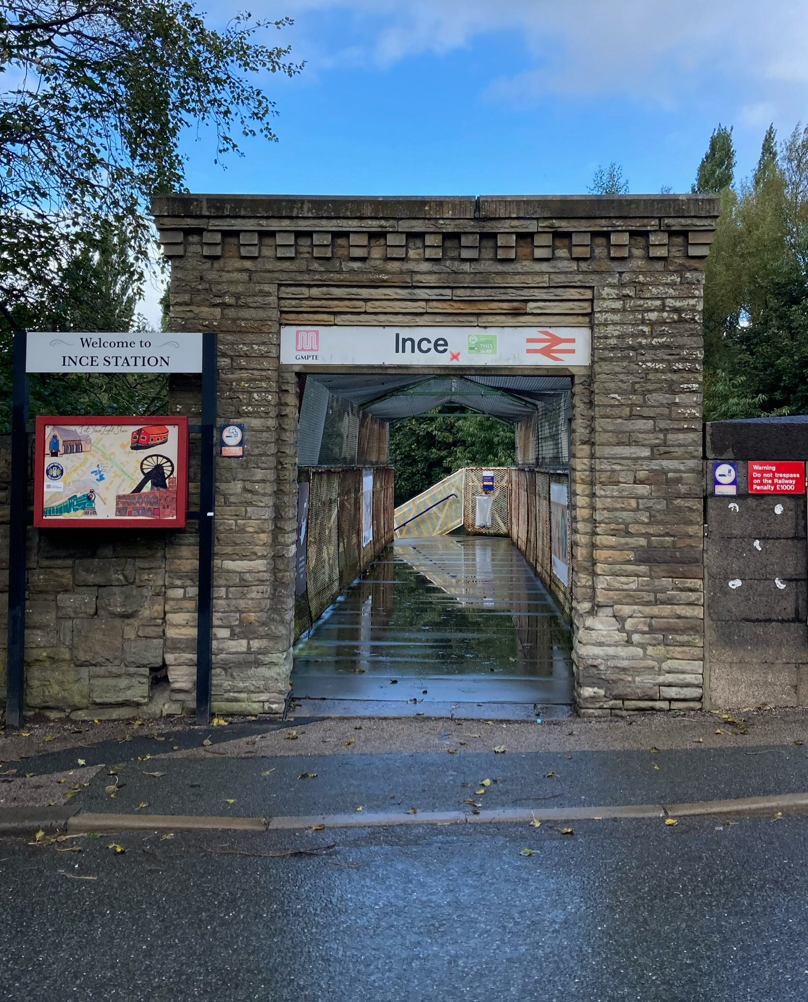
Railway Electrification Works at Ince

Meeting - Thu 1st June, 9.30am till 11am
Christ Church, Ince
The meeting is regarding the work due to be carried out by Network Rail, which will involve replacing the bridge over the railway on Ince Green Lane, as well as the station footbridge. (Planning App: A/23/95460/18PDA)
Cllr Maureen O’Bern will be attending the meeting and has offered to ask questions on residents’ behalf if they can’t make it themselves - Contact. (FB discussion )

Started: 27th May 2023 at 14:51
Last edited by jo anne: 31st May 2023 at 09:01:10
This old sandstone arch may be replaced by a ‘new concrete arch with stone slip cladding & coper’ (possibly re-using the existing stone), when the bridge is modified.
Replied: 27th May 2023 at 15:09
It’s the community info drop-in tomorrow, Thu 1st June, 9.30am - 11am. The church’s food pantry will also be open ![]()

Replied: 31st May 2023 at 19:28

Will you be in attendance Joanne? Keep us up to date wont you.
Replied: 31st May 2023 at 21:22
Unfortunately, I can’t make the drop-in today, First Mate.
Replied: 1st Jun 2023 at 07:54

You drop-out !
Replied: 1st Jun 2023 at 10:01
![]()
![]()
Replied: 1st Jun 2023 at 13:21

What a dump that station and area looks like ! G.B.
Replied: 1st Jun 2023 at 13:36

Golden Bear
I cannot speak about the station, apart from the fact that it is going to be upgraded with the line, but as regards your description of the area, I would say that your comments are a bit harsh, that part of Ince, which is on the border between Higher Ince and Lower Ince, with the old Ince Town Hall, a few yards away from the station, is no better or worse than many other areas around Wigan.
Years ago when the wagon works was in full swing, the area to the east of the station would have been heavily industrialised, but those areas are slowly but surely being taken over for new housing.
Golden Bear
Yoo can be a very rude man 
Replied: 1st Jun 2023 at 14:26
I know TOMMY i can't help it ,there is something inside of me which has to tell the truth so be it ,amen!G.B.
Replied: 2nd Jun 2023 at 14:19
Golden Bear
But I don't agree with your version of the truth, I could tell you of areas within Hawkley Hall which are a dump, for instance behind the shops on Carr Lane, areas within Worsley Mesnes, Lamberhead Green, Beech Hill, Swinley, Central Wigan, all areas have their 'dumps' but yoo are picking on Ince because of stereotypes, but that part of Ince around the station is not a dump.
Replied: 2nd Jun 2023 at 14:58

Is it, like beauty, a quality which resides within the eye of the beholder?
Replied: 2nd Jun 2023 at 15:03
No, it's bloody not, it's not a dump.
Replied: 2nd Jun 2023 at 15:15
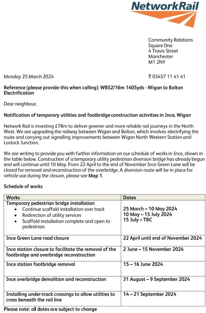
Preparations are underway for the bridge’s demolition - I think the closure of the road bridge will be from 22nd April.

Replied: 4th Apr 2024 at 18:50
I wonder if the new bridge will be wider than the old bridge, which will do away with the need for those traffic lights.
I remember the bridge being a two way bridge with no traffic control, but it was a bit narrow, so you had to watch what you were doing when driving along it, a bit like you have to be careful with the oncoming traffic, when driving under skew bridge on Warrington Road at Newtown ![]()
Replied: 4th Apr 2024 at 21:30
Never understood why traffic lights have never been installed at Skew Bridge when the opening is not big enough to accomodate two HGV's going in opposite directions.
Replied: 5th Apr 2024 at 08:06
Sadly, the stone arched bridge pictured - formerly a canal bridge over the filled-in Ince Hall Branch of the Leeds and Liverpool Canal - is to be lost. The Rev. Long commented somewhere that had the canal bridge been listed, it would’ve been spared.
A thread about the canal branch - WW Album

Replied: 5th Apr 2024 at 11:44
Jo Anne
According to the plans the old stone canal arch is to remain, the road through that arch is the vehicular access to those houses down below at the side of the bridge approach, the access is via The Grove to the old Conq and I am sure as an Incer you will know what the Conq was ![]()
And then the road at the side of the old Conq to the stone arch is actually called Canal Street, it is only the section which crosses the railway lines which is being replaced, the only other thing being that the gap in the wall and steps down to Canal Street on the Higher Ince side of the bridge are being removed.
Replied: 5th Apr 2024 at 14:59
Phew, that’s great news, TTS, very happy to stand corrected! ![]()
Replied: 5th Apr 2024 at 16:47
![]()
Replied: 5th Apr 2024 at 20:03
Replied: 8th Apr 2024 at 15:37
My wife lived in Canal Street as a little girl from 1966 until the houses were demolished in the early 1980's The road that runs from the site of the Old Conq to the old canal bridge is incorrectly referred to on modern maps and by some locals as Canal Street. Canal Street only ever had 6 houses in total. They all had even numbers 2 to 12 without any odd numbered houses being referenced or recorded on historic census entries or land surveys. They ran parallel to the canal itself on the piece of land you can see today between The Grove and the entrance to Foster's Playing Fields. This is clearly shown on older maps of the area. The houses that once stood on the road from the Old Conq pub to the canal bridge/Fosters playing fields were more than likely on Ince Green Lane even though down the side of the bridge but they were definitely not in Canal Street.
See old map here: Map link
Replied: 9th Apr 2024 at 17:08
Last edited by JTM: 9th Apr 2024 at 17:49:20
JTM
Looking at this map from 1914 LINK I can see what you mean about Canal Street running parallel to the canal behind the old Conq Pub (Conquering Hero) ![]()
Replied: 9th Apr 2024 at 17:23
Thank you Tommy. I have posted photos etc showing Canal Street elsewhere on Wigan World here:
Canal Street
If you look at the photo of the canal bridge arch showing the wooden stump in front of the red car, I have used the old side by side mapping archives to deduce that this stump is more than likely a remnant of the footbridge that crossed the canal leading to an old inn called The Railway Inn which is shown on your map link.
Interestingly originally there were only five houses on Canal Street, numbers 2 -10 as can be seen at the older side by side map here.
Map link
My wife and her family lived at number 12 which was added to the terrace row sometime between 1891 and 1901 If you look at the photo in my own postings, you can clearly see the different coloured bricks of their house and that it is double fronted.
Replied: 9th Apr 2024 at 17:33
Last edited by JTM: 9th Apr 2024 at 20:52:33
JTM
Thank you for those pictures and I can see what you mean by the different colour of bricks, but as regards the wooden stump, I am thinking that it might have been a mooring post, for barges to tie up to, but it is very close to where the bridge would have been.
Replied: 9th Apr 2024 at 18:12
My pleasure Tommy, you could well be right about the stump being a mooring post but when I looked carefully at it, there are no signs of rope grooving as per other mooring posts I have seen elsewhere.
Replied: 9th Apr 2024 at 20:27
Thanks for all your interesting information, JTM. I’ve noticed the wooden post/stump before and thought it must be a canal relic.

Replied: 9th Apr 2024 at 21:39
![]()
Replied: 9th Apr 2024 at 22:11
Jo Anne
Thank you ![]()
JTM
I took a picture of a similar but bigger wooden post at the Wigan Pier Basin, taken from the wooden footbridge there.

But that basin is where wide beam barges used to operate, which would be a lot bigger and heavier than the narrow beam barges used on the Wigan Flight of locks and canal at the Ince Green Lane bridge, so that stump at Ince could have had metal rings attached to it when it was in use ![]()
Replied: 9th Apr 2024 at 22:28
Thank you Jo anne and Tommy. In your photo Jo anne, the stump looks more upright that it is now. I wonder if it is the ground sinking into the actual canal bed that has tipped it slightly? The houses on Canal Street and those on The Grove near to the Old Conq pub were demolished because of unstable ground beneath them. Some of the families, including my wife's, moved to Darlington Street East in Scholes, to the houses set back from the road next to the Silverwell pub. The family of the girl on the right in the photo of Canal Street in 1967 being one of them. Her brother still lives there apparently. I will post more here as I uncover the history of the area. John
Replied: 9th Apr 2024 at 23:49
Here are some interesting old Ordinance Survey photos of Ince Green Lane taken in the 1950's The photos display at the bottom of the page underneath the map. The starting photo is on the railway/canal bridge looking south, with the next one showing the entrance to The Grove.
Ince Green Lane
The following link takes you to the 1939 Survey record for Canal Street. If you look carefully, you can see that the six houses are numbered evenly between 2 and 12 there are no odd numbered houses. If you click the previous page arrow on the left of the image, you can see records for The Grove.
1939 Survey
The following links show the old canal branch still partially filled with water behind the houses on The Grove. I walked through the entrance gates to Foster's Playing Fields and then pushed through the bushes/undergrowth on the right hand side of the path to take the photos.
Photo 1
Photo 2
Photo 3
Replied: 10th Apr 2024 at 14:47
Last edited by JTM: 10th Apr 2024 at 16:13:28